Our project to photograph and measure waterfalls we visit

Friday, April 22, 2016

Little Nestucca Falls

On Wed., April 20, we drove and hiked to the Little Nestucca Falls. The story of this adventure is on my Ramblings blog: http://lindafink.blogspot.com/2016/04/our-latest-greatest-waterfall-adventure.html

The falls is located within Oregon State Forestry land with no trail or easy access. We took FS road 2281 from Sourgrass Summit on Hwy 22 into the northwest corner of Section 10 and hiked from there down to Fall Creek and followed it to the Little Nestucca River junction. The falls begins shortly after Fall Creek and the Little Nestucca join together. lat/long 45.078483 -123.753433

Lots more photos and a description of our route in and out are on the link above.

Below is the first drop from two angles.


And the entire falls...


The Northwest Waterfall Survey says it is 75 feet tall, but that includes three separate cascades. The top one is a sheer drop that Johnny estimated at 25 feet. The second is a cascade of maybe 35 feet. The third is a less steep cascade of, presumably 15 feet, although these are all rough estimates. Taken together, the falls are spectacular.

Saturday, April 16, 2016

Cosper Creek Falls and Kissing Rock


On April 13, 2016, we drove to Cosper Creek Falls on Hwy 22, Hebo Rd., just north of Valley Junction where Highways 18 and 22 separate. In the tight bends a pull off on the east side of the road is a popular spot for locals to pull into. A large boulder sits there and is usually painted with graffiti on the flat side.. and then covered over with more paint and so on. But the side toward the road is not usually defaced. The rock has quite a history locally.

Fifty or more years ago, that road was seldom traveled. Teenagers used to park there with their girlfriends, hence the name Kissing Rock for the big boulder that sat within view of the 10 foot waterfall just over the bank. However, at some time back then, someone blew up the rock. Apparently the deed was done by one of the teenagers who became, like most of the teenagers back then, a logger. And so, for many years, there was no rock. Depending on who is telling the story,  either the same grown-up logger or another logger moved a big boulder in some years back to replace the one that had been blown to smithereens. And so Kissing Rock has its rock back.


Although the pull-out was used as a dumping ground for years, now some local people keep it pretty well picked up. The view of Cosper Creek and the falls from that level pull out is lovely. However during heavy rains, the creek becomes quite muddy. In the very dry end of summer, the creek becomes a trickle.

We happened to take our photos on a day when the creek was running full and clear.


Sunday, April 3, 2016

Bible Creek Falls


 On March 31, 2016, we hiked down to the roaring Bible Creek Falls. The sound is the only way to find it as it is many feet below the road and completely out of sight. We had spotted the area on a previous evening when mist from the falls drifted up into sight. We had clocked the spot at 1.2 miles from the junction of Nestucca River Road and Bible Creek Rd. Just past an old red 4 on a mile marker is a bend in the road and then a sort of grassy pull off where we parked. We hiked straight down from that pull off and arrived at the top of the falls. We could not see if there was more to the falls than this initial drop of maybe 20 feet. It then flattened out for another maybe 20 feet and disappeared.


  So we hiked downstream to where we could see the second drop, which is mostly occluded by logs. The creek is forced to go on either side of a massive log jam and also under it, surging out in froth below one vertical log. I hiked down to where I could see the entire falls, or as much as can be seen from any one spot. The upper falls is above the log jam in the photo below, the flat spot invisible behind the log jam, the water going around the log jam on both sides is barely visible, and then the lower drop with its log in the middle of itself.


Johnny stayed where he could see the top of the falls... and me as I made my way along the cliff.


I had a little more view of the flat below the top falls from a position higher on the steep (nearly vertical) cliff.


 On my hike back out of the gorge, I came to a spot where I could see the falls between trees.


Without having seen the mist rising from the falls that one evening, it would have been a challenge to find this falls. It is louder above but since you cannot see the falls until you are almost to it, it takes an act of faith to head down that steep, wooded and brushy cliff. We were not able to measure it, but the 56 feet on the Northwest Waterfall Survey page seemed about right, counting all three drops.


Sunday, March 6, 2016

Alder Glen Falls

This falls is easily seen from the Alder Glen Campground on the Nestucca River Rd. Info from Northwest Waterfall Survey on this 30 foot veiling horsetail falls is here: http://www.waterfallsnorthwest.com/nws/falls.php?num=4906

We visited and took photos on Feb. 13, 2016.


The campground has a wheelchair accessible dock just downstream of the falls. Usually, an American Dipper can be seen from that spot.

Saturday, March 5, 2016

Burton Creek Falls

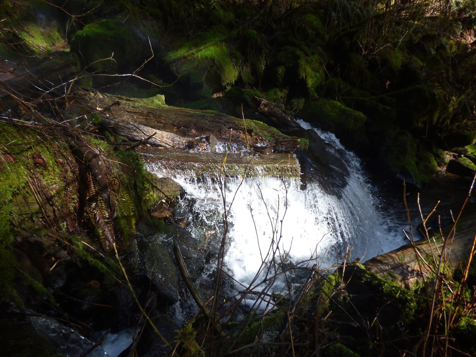
On March 5, we drove up Wind River to try to follow the new Confederated Tribes of Grand Ronde map that Johnny picked up from the tribal forestry office. It was created for tribal members to locate wood cutting areas, and has road numbers on that are not on our old forest map. By following it, we were able to find the headwaters of Burton Creek. We stopped at an old road with the number 770B on it just past Burton Creek. I decided to hike up the road, since it paralleled Burton Creek. In a very short distance, I heard a waterfall! And soon was able to see it. Woohoo!


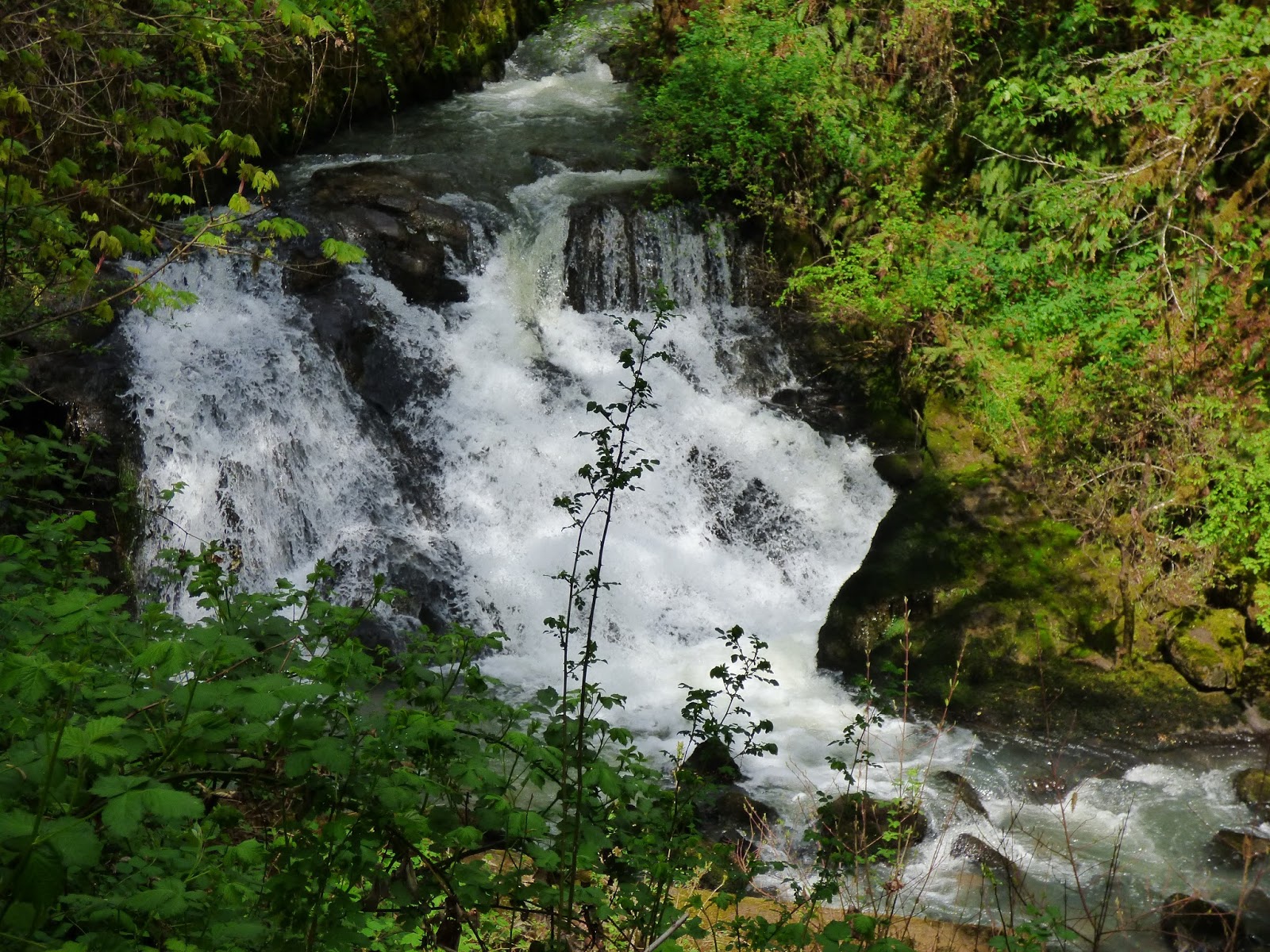
 We hiked down so Johnny could try to figure out the height with his triangle system. He uses a clinometer to find a point exactly even with the top of the falls and another point exactly even with the bottom of the falls. We then measure the distance between those two points. With some math magic, he calculates the height of the falls. By Johnny's measurements, it is 35.5 feet high.


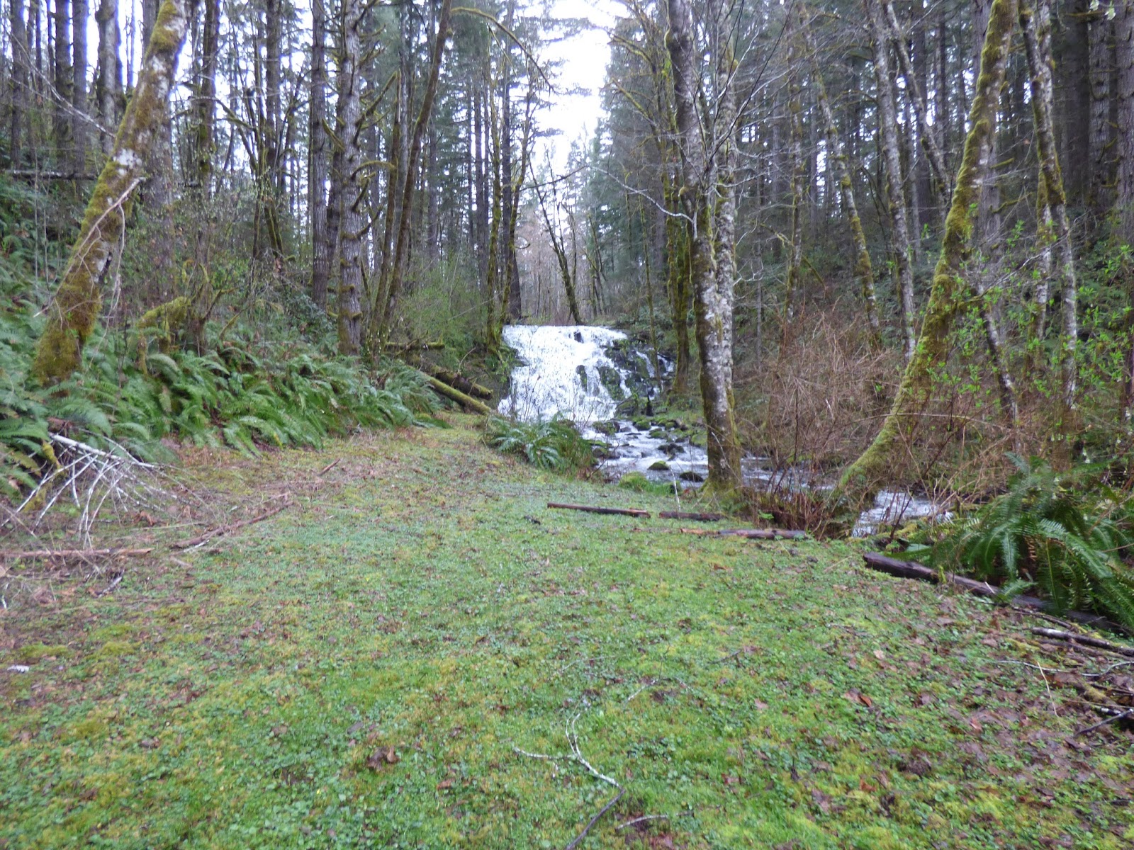
I just took a lot of photos. Such a pretty falls and so close to a road. It's steep to hike down to the base of the falls if one wants to get up close, but it's quite viewable from the old road 770B on top of the bank (first photo above).


Using itouch maps, I came up with virtually the same lat/long as the Northwest Waterfall Survey has so am using theirs.

45.16833

-123.586694

http://www.waterfallsnorthwest.com/nws/falls.php?num=4081

The reason we could not get to this point in February when we came up from Willamina was because the 750 road was blocked off. The blockade was gone today. If that road is unblocked, the falls can be reached either from Grand Ronde up Agency Creek Rd. to Wind River (200) to 770 to 700  to 750 to 770A, where 770B is located. (A guide who knows the roads is advisable.) Alternatively, one can come up from Willamina on Willamina Creek Rd. to Coast Creek Rd. to 700, 750, etc. But there is no number at the 700/750 junction and that's where the 750 was blocked when we came in Feb. The tribal map shows 760 road coming off the 700 to reach 770 but as far as we can determine, it does not in reality. The falls is on tribal land but the roads are open to the public most of the time. During last summer's drought, the reservation lands were closed because of extreme fire danger.

It is a lovely falls and we were thrilled to find it today.

The Real Gilbert Creek Falls

After stumbling upon Burton Creek Falls (another post) on March 5, 2016, we drove down to Coast Creek and past the falls we had seen in Feb. that turned out not to be Gilbert Creek Falls. This time we took a logging road that paralelled the creek we thought was Gilbert Creek, which turned out to be Canada Creek, parked at the gate and walked a mile plus looking for a waterfall. None was to be found.

So we hiked back to the van and drove on down Coast Creek past a house that Johnny had, back in February, thought probably had a waterfall behind it, but we could not see past the line of trees along the road. As we passed there were two people standing by the driveway and one hollered "Johnny Fink!" We thought he must know Johnny so we backed up. He had read the side of Johnny's Roustmobile (Dodge Van) with his name on it and wanted to know who Johnny Fink was and what a Roustmobile was. So Johnny explained that a Roustmobile was what a Roustabout drives and Johnny calls himself a Roustabout since he did odd jobs plus roofing. The guy wanted to know if we lived up the road. We explained that we were out looking for waterfalls and had heard about Gilbert Creek Falls but could not find it. He told us the only way to see it was from behind his house... or from his living room. And invited us to walk back and take a look while he and his friend hiked up the road a piece. So we did!

Wow. What a beautiful falls.


And what a spectacular house Harold Miller built himself twelve years ago. He said a lot of people were annoyed that he built a house right in front of the waterfall, blocking their view. He planted evergreens along the road, too, so it's difficult to even get a peek anymore. But he was quite friendly and invited us to take a look and even, when he and his friend returned, come in and view it from his living room. We declined the latter invite but I'm sure the view is spectacular. Standing by the waterfall, his living room looks right down the path he maintains and would have a wonderful view of the falls.


So, Gilbert Creek Falls is right where it says it is on maps, but is totally on private property, so I'll not post directions. Nor did we try to measure it. Our guesstimate is about 30 feet high and at least that wide. We are grateful to Harold Miller for inviting us to view it today.

http://www.waterfallsnorthwest.com/nws/falls.php?num=4082

Sunday, February 21, 2016

Mistaken Identity for "Gilbert Creek Falls"

On March 5, we drove again to this area and discovered the *real* Gilbert Creek Falls. We had two things wrong in our Feb. 20 visit. First the Falls that flows into Coast Creek is not the one called Gilbert Creek Falls. Second, the stream just downstream from the falls that flows into Coast Creek is not Gilbert Creek. It is Canada Creek. The real Gilbert Creek Falls is, appropriately enough, on Gilbert Creek. My blog post titled "The Real Gilbert Creek Falls" has photos and info. It is quite spectacular... and quite inaccessible. We were invited to see it by chance. Below is what I wrote on Feb. 20 about the falls we mistook for Gilbert Creek Falls.

On Feb. 20, 2016, we drove to Gilbert Creek Rd. and Coast Creek Rd. looking for the falls called Gilbert Creek Falls in the Northwest Waterfalls Survey site. We found a lovely waterfall near but not connected to Gilbert Creek. It flows off the side of a ridge into Coast Creek just a few yards upstream... and on the opposite side... from where Gilbert Creek flows under Coast Creek Rd. and into Coast Creek. The falls is located across Coast Creek from a private residence. Trees lining Coast Creek Rd. make it difficult to see the falls. Once they leaf out, it will be impossible to see it.

Hopefully we'll be able to meet the property owners some day and ask what *they* call that waterfall. I doubt very much they call it Gilbert Creek Falls.

Because of the trees lining the road, I was unable to get an unobstructed view of the falls. I climbed the bank on the opposite side of the road from the house and creek and falls and took photos through the branches. Not all of the waterfall is visible as a result.

The maps do not show the creek that creates the falls so I was unable to pinpoint the GPS. My guesstimate is
45.156293
-123.527095

Property the waterfall is on and property where it is visible from is all privately owned (according to our color-coded forest maps) so the waterfall is not accessible except in a drive-by on the gravel Coast Creek Rd.


Monday, February 15, 2016

Niagara Falls and Pheasant Creek Falls

The Niagara Falls trail goes to two waterfalls, neither one on Niagara Creek. Niagara Falls got its name from its proximity to Niagara Point, a 1,732 ft / 528 m mountain peak near Willamina. It is the first waterfall the Niagara Falls trail arrives at, but is not the more spectacular falls at the end of the trail. That one is Pheasant Creek Falls.

We hiked to both falls on 2/13/16 and took photos. Our rough measurement of Niagara Falls was 103.5' which seemed plausible considering the official height of the Pheasant Creek Falls is 124 feet. However, the official height of Niagara Falls, according to the World Waterfall Database is 122 feet! I could see no way these two falls are so close to the same height. The U.S. Forest Service, on the other hand, says it is 107' which is much closer to our approximation. I wrote to Bryan Swan, who does the Northwest Waterfall Survey and he explained why Niagara looks so much shorter than it really is:

"It's an illusion called foreshortening - essentially the tendency of something to look smaller because you're so close to it.  I honestly questioned my measurement of that one as well..., but I measured it with a laser rangefinder and it's proven over the years to be exceedingly accurate (with a margin of error of about 15 feet or so)."

We'll have to get a laser rangefinder!

Here are two photos of Niagara Falls taken from close to the bottom of the falls. (The trail passes just below the falls.)


For more info on this falls, see the Northwest Waterfall Survey: Niagara Falls
http://www.waterfallsnorthwest.com/nws/falls.php?num=4084

The official sites say Niagara Falls is seasonal with a 7 month run. However, we were there on 8/12/2012 and there was water flowing over both falls, not much but some. Probably in very dry years, it does dry up late summer.

World Waterfall Database: http://www.worldwaterfalldatabase.com/waterfall/Niagara-Falls-4084/


Here are two photos of Pheasant Creek Falls, taken from a distance, on 2/13/16.


The below photo was taken from a slightly different angle, making it look like the falls actually has two drops, which it does "officially" with the tallest drop 106', upper drop 18'.


Northwest Waterfall Survey website: Pheasant Creek Falls 
http://www.waterfallsnorthwest.com/nws/falls.php?num=4079 

World Waterfall Database: http://www.worldwaterfalldatabase.com/waterfall/Pheasant-Creek-Falls-4079/


Friday, February 12, 2016

West Fork Yoncalla Falls

Feb. 12, 2016, Johnny and I hiked the short trail to the falls on the west fork of Yoncalla Creek. Johnny used his Suunto Instrument to measure the angle between top and bottom of the falls while I hiked to the base of the falls with the end of the tape measure to give him the distance from him to the falls. He then computed the height of the falls to be 20 feet to the first drop. The falls then pools (along with a mass of logs) for about 5 feet before falling another 5 feet to the creek bed where it continues to tumble down over rocks to join the main fork of Yoncalla Creek.

lat 45.160889
long -123.657107

Below is the view of the falls from the trail. The trail continues down to the creek and across the creek (if you can make your way across by hanging onto logs and wearing boots) then winds its way up to the road above. That road crosses the creek upstream, above the higher and inaccessible Yoncalla Falls, and goes back downstream to where the road to this trail cuts back again along the creek. Waterhole 8 is the pool below the road culvert at the start of the trail to the West Fork falls. Most of the locals call this smaller falls Yoncalla Falls. Probably since the much higher one on the main branch of Yoncalla Creek is not visible from anywhere except at the bottom of a very steep and wooded bank.


I took this photo from the base of the West Fork falls. A logjam creates a pool at the foot.


Below the logjam, the water falls another 5 feet.


Here is the upper and lower tier.


I hiked across the creek to get a view of the top of the falls, which is not visible from the trail side.


Since the top of the falls is hard to see, I zoomed the camera in and held it high over my head to get this shot.


Here is upper and lower drop from the north side of the creek.

This creek runs all year but is much lower in the summer with the creek much easier to ford then.

Yoncalla Falls

On Feb. 12, 2016,  I hiked to the bottom of this falls. It is not visible except in pieces from the road that crosses Yoncalla Creek above the falls.

I measured this falls, which we call Yoncalla Falls, by lowering a measuring tape from the top of the falls to the bottom. Johnny stood on the opposite side of the creek where he could see when the tape hit the bottom.  There is no trail and access to the bottom of the falls is very steep. After measuring from the top, I climbed across the creek, as the bank was too steep on my side, and down the opposite bank to the creek, crossed the creek to get a clear view and climbed on a fallen log to take these photos. 

lat 45.161366
long -123.655621

height 40'

This first photo was taken a little way downstream where the bank on the right side of the photo obscures part of the waterfall.


I worked my way closer on the far bank to get a clear view and took these photos.


More (and somewhat different info) on the Northwest Waterfall Survey site:
http://www.waterfallsnorthwest.com/nws/falls.php?num=22559